Showing posts with label maps. Show all posts

Monday, January 28, 2013

That Map of Handgun-Permit Holders

Even the techie online mag cnet.com is debunking the map of pistol-permit holders published by the Journal News:

The Journal News, a local New York paper, decides to post a map of all those who own handguns in the area. Like so much that's online, it contains errors -- massive errors.

...and:

Oh, and I almost forgot to mention that some of these permits dated from the 1930s.  

Friday, September 14, 2012

Warp Drive

Who would have thought that the Virginia Transportation Dept, of all people, would have a sense of humor?

Orbital Sciences is on that road.

Wednesday, July 4, 2012

Hot Weather Ride


View Larger Map

And not far away:
Meet me at the corner of Browning and Garand.

There really is such a place, at Quantico MCB.

Tuesday, December 13, 2011

And Just Over The Border...


...is the peaceful village of Moyock, NC.

On The Border


Thanks to reader Bob, we have one more Wullenweber. This one on the Virginia/North Carolina border (the horizontal gray line is the border.)

This one looks like it's been converted into a secret squirrel site.

Or a Walmart.

Sunday, December 11, 2011

Wullenweber Antennas

Sobe, Japan

These are very large arrays for high-frequency reception and direction-finding, mostly by governments. Here is the Wikipedia article.

All of the installations were originally super-secret, but most have been dismantled and only a few are left, all of them inactive.

In addition to RAF Credenhill in the previous post, these Wullenweber sites remain:

Chicksands, UK

Elmendorf AFB, Alaska

Misawa, Japan

Imperial Beach, California

This one has an interesting history. Built in Karamursel, Turkey, it was dismantled by the Turkish government in 1977 in retaliation for a U.S. arms embargo. That was 34 years ago and it's still easy to spot.

They're anachronisms now, but as this 1955 snapshot shows, security at Misawa was serious.

Saturday, November 26, 2011

What Color Is The Boathouse At Hereford?

There seem to be many different possible answers to that time-honored question.


But first, what is this Big Round Thing?

And what is this Little Round Thing?

They've got their own orchard, we know that.

And some sort of Big Square Thingy. Avec flagpole.


Nice antenna.

What say you, Bobbi? Appears to me to be a broadband ten-element high-frequency Yagi. I'd love to own one.


There's a double fence around the whole place, with camera towers every hundred meters or so.

And a bit farther down the road we see the antenna in the distance. More like twelve to fifteen elements, I'd say. Like the one at the Pentagon. Maybe they talk to each other: "dit-dit-dit-dit-dit..."

They've got lots of stuff, but I don't see a boathouse. Musta been one of those trick questions.

Hey, what's that weird tower on the horizon? How'd I miss that?

OK, there it is. Maybe that's the mysterious boathouse.

"'ello, 'ello, 'ello! What's all this, then? That's as far as you go, Yank. Nothing to see 'ere. Just turn your fancy camera car around and get yer arse back to Cupertino."

"You think we're barmy? Get lost!"

"Um, Constable, is there a boathouse around here?"
"Bloody git!"


See for yourself here.

Monday, September 26, 2011

24 Terabits A Second

Three submarine fiber cables come ashore in Hermosa Beach, CA...

And make their way to this ratty-looking telephone pole. Notice the red spray-paint on the pavement: "Before you dig, call Miss Utility."


View Larger Map

Thursday, May 12, 2011

Maps and GPS

Last week I had a flat tire on my bicycle and had to walk home. This simple task was complicated by the layout of the suburban streets hereabouts. I could get to within 100 yards of my home, but could not reach it without crossing private homes and climbing backyard fences. The shortest alternate route was a two-hour walk, which I did.

It seems the local pols have had a policy of closing streets and erecting fences to limit motor vehicle traffic in residential areas. And it also prevents bicycle traffic and sometimes even foot traffic.

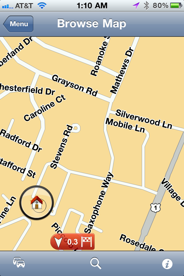
At the time, I asked my GPS to find me a quick route home, but the suggested route directed me to pass through a barricade at a closed intersection. This barricade even had a chain-link fence with a narrow right-left-right pedestrian chicane, to prevent folks from bringing bicycles through!

Here's the view from Tom-Tom:

I was at the intersection of Mathews and Grayson and I wanted to get to the little "home" icon. But no, the road is closed, as shown on this view provided by Google Maps:

Silverwood Lane is a blocked-off alley, with dozens of small trees growing there, and completely impassible.

Tom-Tom does allow users to make "corrections" to their maps and now when I call up the same intersection I see this:

Here's a closer look:

Silverwood Lane is still there, but Tom-Tom will no longer try to route me through this intersection.

Today I bicycled 2 miles to the local Starbucks for breakfast and I crossed over I-95. As I did I noticed that the northbound lanes were jammed but the southbound lanes were moving well:

Facing south, with northbound traffic on the left and southbound traffic on the right. The two center lanes are the reversible HOV commuter lanes that drove Jay G so crazy when he was here a couple of weeks ago: "They go one way in the mawnin', and the other way in the awftahnoon! Those Vahginyuns ah wicked crazy!"

And here's the traffic view from Tom-Tom at the same spot:

The orange arrows on white background indicate a traffic jam to be avoided. And only in the northbound lanes. My Blackberry using Garmin GPS could not differentiate between the lanes and simply reported the whole highway as jammed, even if traffic in one direction was moving normally.

Sunday, March 20, 2011

Long Ride

Friday was a beautiful day. Bright overcast, high seventies. No wind to speak of. So I took a long bike ride. Packed a lunch and set off from the old Lorton Prison, now called the "Workhouse Art Center". I pedaled up route 123 toward Fairfax along the paved bike trail. It's called Ox Road in Prince William County, and Chain Bridge Road in Fairfax County. Then back by the same route. I pedaled for 4:45 and rested for 25 minutes to cover nearly 35 miles. Not the longest trip I have ever taken but a grueling slog; I haven't biked in months and I'm out of shape.

Check out the display from the iPhone:


Notice how little battery is left after less than 5 hours of continuous GPS use. That battery was in a car charger until the minute I pushed off at 12:20. I brought along a neat little USB charger like this one:

But the iPhone didn't like it; it reported, "The charging device is not supported..." So the iPhone was nearly dead after five hours. This is an app called Cyclemeter.

Here's a snapshot from near the end of the trail:

Waples Mill Road in Fairfax. Just a mile from the NRA's HQ the country is surprisingly wild; I saw a large adult red fox a hundred yards farther down the road. And an eagle carrying a squirming fish in its talons.

The NRA building is at the 16-mile point. As you can see, I had some trouble finding a bicycle route across I-66!

When I got home I was exhausted and fell asleep for a couple of hours. Then I took a shower and the salty taste of the water surprised me.

Thursday, January 6, 2011

Tom-Tom For iPhone 4


I've been using this app for iPhone 4 for about a month now. For the last two years I have been using Garmin Navigator on a Blackberry, which I really liked, in spite of its shortcomings.

In terms of the user interface, there's no comparison: the Tom-Tom screen is nearly triple the size of the Garmin, and sharper, too. The voice directions from the iPhone are better, too; much, much better. The Blackberry/Garmin voice directions are often punctuated with bursts of digital static, but the iPhone/TomTom voice directions are exceptionally good.

Note in the image above, in the upper left corner, the music symbol. This is the gateway to your iTunes player in your iPhone. If music is playing when the Tom-Tom speaks, it will gently dip the audio level while it reads the directions, then gently raise it back.

On the other hand, note the destination: Starbucks Woodbridge. The street address is 2447 Prince William Parkway. My location is indicated by the blue triangle and the checkered flag is my destination. And note that the Tom-Tom is directing me to take a sharp left turn, thru the guardrail, from the cloverleaf to the Starbucks. This is not good.

The Tom-Tom stores all of its maps inside the iPhone, so even if there is no phone coverage, there should be map coverage; I haven't tried it yet, but I will. Tom-Tom updates its maps pretty often, and you can select whether you want to download updates automatically, manually, or on a schedule. I've had it about a month and I've downloaded updates (maps and programs) three times.

The trip planning feature is great. It allows you to select alternatives by (among other things) avoiding certain roads; hint: avoid US270 and US68 to get from northern Virginia to Indianapolis without going thru Maryland - or, at least, avoiding it as much as possible.

Tom-Tom uses automatic reports from users to calculate real-time road speeds on highways and spot traffic jams: if the users on that road are consistently traveling at 15 mph, in spite of a speed limit of 55 or higher, Tom-Tom routes other users around that slowdown. On my way home from Indy, the Tom-Tom suddenly came alive and predicted a 50-minute delay and proposed an alternative; I pressed "Yes" and Tom-Tom directed me to take the next exit. Immediately, the two trucks in front of me began flashing their right-turn signals and got off at the same exit. I have no idea if they had Tom-Toms, but it sure looked likely to me.

Tuesday, September 7, 2010

Rural Bicycling II


Today I saddled up and took a long ride on the bike, about 20 miles round-trip I believe. Crossed the Shenandoah River at a little one-lane bridge.

The GPS didn't start working for the first three miles. Blackberry GPS's are like that: they expect to have a working data connection, and if they don't have it, they'll keep looking, sometimes for hours, even though the GPS satellites are coming in loud and clear. Oh, well.

Here's the aerial view:


This was the most exhausting ride I have ever done. Nothin' but hills. I pedalled up one hill on the opposite side of the river from an elevation of 550 feet to an elevation of 850 feet. The road was "paved" with dusty, powdery dirt and gravel, and it was so steep that it was difficult to balance the bike: I had to lean forward to avoid toppling over backwards, but if I leaned forward too much, the rear wheel would lose traction. At the top of that hill, I decided, "OK, that's all I can take!" and I turned around and descended the hill; that's the steep drop in the graph.

Wheeeeee!

Over thirty minutes to climb, and then back down in about two minutes.

On the way back I stopped at the little campground store and bought an orange Popsicle: 35 cents. Best-tasting Popsicle I ever had!

I was gone four and a half hours and I was near collapse when I got home. I had plenty of water; I took a Camelback with three trays of ice cubes... I'm just outta shape!

Tuesday, July 27, 2010

Rural Bicycling

Started at the eastern end and worked my way west, then returned. A 14-mile round trip. Very hilly; about 1200 feet of elevation at the eastern end and 743 feet at the western end.

In the upper left corner you can just see one of the many bends of the Shenandoah River.

At about the mid-point of the trip there is a very sharp hairpin turn. It's a lot of fun on a bike because it's sharply downhill on the way out; not so much fun to climb it on the way back.

I'm thinkin' about puttin' a still in my back yard. But how to keep the revenooers away? Any suggestions?

Wednesday, March 10, 2010

Dum-Dum and Cordite

Do you suppose they still make it in the original factory!?

Over at Tam's there's a thread about expanding bullets that sent me off on a web-wander and here's some of the places I went and the thangs ah seen!

Over at The Box Of Truth I found this picture:

Caption:

The one on the left is a round from the Indian ammo factory in Dum-Dum India.
The middle one is a round of WRA, loaded with Ball powder, surprisingly.
The one on the right is from the Royal Laboratory in Woolwich Kent, England.
It was loaded with the Cordite that you can see there.
You can also see the small piece of cardboard that covered the Cordite.
Apparently there is such a city in India, actually a municipality of the larger city of Kolkata. Dum Dum was the site of a British armory and jail. Gandhi was jailed there in 1946.

"Royal Flying Corps near Dum Dum, India, 1930"

They've got a modern rail station there.

FirstWorldWar.com says,

The 'dum-dum' was a British military bullet developed for use in India - at the Dum-Dum Arsenal - on the North West Frontier in the late 1890s.

The dum-dum comprised a jacketed .303 bullet with the jacket nose open to expose its lead core. The aim was to improve the bullet's effectiveness by increasing its expansion upon impact.

The phrase 'dum-dum' was later taken to include any soft-nosed or hollow pointed bullet. The Hague Convention of 1899 outlawed the use of dum-dum bullets during warfare.

During the First World War the Belgian government faced German charges of having used dum-dum bullets in battle. Kaiser Wilhelm II wrote a telegram to U.S. President Woodrow Wilson on 7 September 1914 protesting such use; the Belgians strongly denied the Kaiser's charges.

The city of Dum Dum is still a going concern, as can be seen from this commercial notice I found, an RFP for Hewlett-Packard computers:


Street vendor in modern Dum Dum.

Monday, January 25, 2010

Sixty-Five Degrees!

The weather was so warm today that I was able to wear shorts on my bike ride. I went about 20 miles in two and a half hours.


Monday, November 9, 2009

Vanished Persian Army Said Found In Desert


The remains of a mighty Persian army said to have drowned in the sands of the western Egyptian desert 2,500 years ago might have been finally located, solving one of archeology's biggest outstanding mysteries, according to Italian archaeologists.

Bronze weapons, a silver bracelet, an earring and hundreds of human bones found in the vast desolate wilderness of the Sahara desert have raised hopes of finally finding the lost army -- 50,000 strong -- of Persian King Cambyses II, buried by a cataclysmic sandstorm in 525 B.C.

Wednesday, November 4, 2009

Ramblin'

On the web I found a local bicycling club that makes and publishes turn-by-turn routes in the Northern Virginia area. Yesterday I selected a 34-mile ramble that includes Lake Barcroft and Lake Accotink, and crosses the Capitol Beltway twice. It's a combination of rolling hills through quiet suburban streets, connected by bicycle trails (some paved and some not) and parks. I used this as a sort of orienteering exercise as much as anything else. Including the ride to and from my house, it was a total of 50 miles. I started at noon and didn't return home until after dark; more than six hours of pedaling. I probably burned over 3,000 calories.

I only averaged about 8 mph due to the hilly terrain and frequent stops to check directions - there are about a hundred turns with directions like "BR TRO Queensberry 0.3 L T@SS Bristol", i.e. "Bear right to remain on Queensberry Drive for 0.3 miles, then turn left onto Bristol Street at the stop sign at the T intersection."

Had a blast! Got stopped by a Fairfax County patrol car; the officer admonished me for deliberately and flagrantly running a traffic light (guilty!), but fortunately it was only a warning and I didn't have to surrender my piece. Brother! That would have been an imbroglio!

Here's a GPS map that I made along the way. The route begins in Bluemont Park in the Seven Corners area and proceeds clockwise. The yellow lines indicate where the GPS unit "lost lock".

Monday, October 12, 2009

The Big Five-Oh!


Went for a fifty-mile bike trip today. It took about six hours, five if you only include the actual biking, 'cause I stopped for an hour for lunch.

Here's a look at the vehicle:
The rear pannier bag carried an MRE, thermos of hot coffee, water bottle and rain poncho. In the front handlebar bag is a first aid kit, pepper spray, tire pump, ID and CHL, keys, phone and $20 bill. The tool kit has a spare tube, patch kits and tire tools, tire gauge and the usual things. The front pannier rack is held to the front fork by six homemade clamps. First gear is a real "stump-puller" that allows the rider to climb hills so steep that you have to lean sharply forward so that the bike won't topple over backwards.

No, I do not wear those goofy tight bike pants. I need pants with a belt.

Is this an impossibly-blue sky, or what?


Let's see if I can imbed a GPS map here:


Hey, it worked! The blue line represents my trip home, except for a 3/4-mile GPS failure (yellow line).